Coords
Advertisement
GridImp
Imports gridded data into MS-MapPoint, to produce attractive data maps. Can handle imperfect data, holes, re-gridding, etc. Can be used to import such attributes as pollution data, seismic hazard, geological information, customer/population
Copan Lite v.11 11
Land surveyors and civil engineers: o Calculate surveys and manage points, effortlessly o Run Copan on Windows 2K/XP/Vista/7 o Use it forever and pay nothing o Choose quadrant bearings or N/S azimuths, and gons or DMS o Create point files
Advertisement

Find Distance Between Multiple Latitude and Longitude Coordinates Software v.7.0
This software offers a solution for users who want to find the distance between one or more latitude and longitude coordinates. Coordinates can be added one at a time or loaded from a text file.
MeshLab for Mac v.1.3.2
MeshLab is an open source, portable, and extensible system for the processing and editing of unstructured 3D triangular meshes.

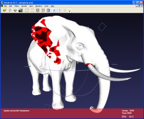
MeshLab v.1.3.2
MeshLab is an open source, portable, and extensible system for the processing and editing of unstructured 3D triangular meshes.